Skip to main content
Home
Historical Maps
World History
U.S. History
Canadian History
Canada (English)
Canada (Français)
Old school history maps
Stories on the Map
Armenia
Assyria
Catalonia
Kurdistan
Palestine
Ukraine
Edmaps +
HISTORICAL MAPS OF AUSTRALIA
Map Collections and Atlases
Blank and Outline Maps of Australia
(d-maps.com)
Australia on the Map
(Australasian Hydrographic Society)
Australia: Historical Maps Collection
(Yale University Library Digital Collections)
Australia: Historical Maps Collection
(Library of Congress)
Australia Maps
(Perry-Castañeda Library Map Collection)
Australia: Map Collection
(Macquarie University)
Australia: Mapas históricos
(Instituto Geográfico Nacional - España)
Australian Rail Maps
Australians - A Historical Atlas
(Academy of Social Sciences in Australia)
Historical Maps of Australia
(National Library of Australia)
Historical Maps of Australia
(American Geographical Society Library Digital Map Collection)
Historical Maps of Australia
(David Rumsey Map Collection)
Maps of Australia
(The University of Melbourne)
Old Maps of Australia
(oldmapsonline.org)
Maps of Victoria
(The University of Melbourne)
New South Wales Parish and Historical Maps
(NSW Land Registry Services)
Queensland Historical Atlas
(The University of Queensland)
Queensland: Historical Maps and Plans
(Government of Queensland)
South Australia: Historical Maps & Plans
(State Library of South Australia)
South Australia: Maps & Plans
Maps of Melbourne
(The University of Melbourne)
Historical Atlas of Sydney
(City of Sydney Archives & History Resources)
Historical maps of Sydney, Melbourne, Brisbane, Adelaide and Canberra from the 1930s, 1940s, 1950s and today
(Time Travels)
Maps
Grey’s Map of Aboriginal Dialects, 1845
(State Library of South Australia)
Australia, 1839
(J. & C. Walker)
Australia, 1846
(John Arrowsmith)
Australia, 1846
(J. & C. Walker)
Australia, cca. 1850
(Edward Stanford)
Australia, cca. 1855
(James Wyld)
Australia, 1856
(G. W. Colton)
Australia, 1856
(Cornelius Cartee)
Australia, 1856
(James Wyld)
Australia, 1858
(J. Bartholomew)
General map of Australia shewing the routes of explorers, 1861
(J. M. Meek)
Map of Australia shewing the routes of explorers, 1863
(J. Hamel)
Australia, 1865
(J. & C. Walker)
Australia, 1869
(G. W. Colton)
Australia, 1873
(J. Bartholomew)
Map of Australia, 1878
(Gordon & Gotch)
Continental Australia, 1879
(Dept. of Lands and Survey - Melbourne)
Australie, 1883
(Marin La Meslée)
Map of Australia, constructed for the use of schools, 1884
(Smith and Son, London)
Australia, 1891
(D. Appleton and Co.)
Australia, 1891
(Rand McNally)
Australia, 1900
(George Philip and Son)
Australia, 1902
(Hermann Haack)
Australia, 1903
(J. Bartholomew)
Western Australia, 1905
(Western Australia, Dept. of Lands & Surveys)
Commonwealth of Australia, 1911
(New South Wales, Dept. pf Lands)
Western Australia, 1911
(Western Australia, Dept. of Lands & Surveys)
Stanford’s General Map of Australia, 1912
Commonwealth of Australia, 1918
(New South Wales, Dept. of Lands)
Australia - A Gigantic Inheritance (A comparative map, 1919)
Australia - Political Map, 1920
(J.G. Bartholomew)
The New Oxford Wall Map of Australia (Population), 1927
The New Oxford Wall Map of Australia (Vegetation), 1927
Australia, 1929
(Touring Club)
Australia, 1937
( Australia - Dept. of Interior, Property and Survey Branch)
Australia, 1942: Her Natural and Industrial Resources
(Leslie Gill)
Popular Series Map of Australia, 1954
(H. Robinson)
Australia, 1959
(C.I.A.)
Australia, 1963
(Australia - Division of National Mapping)
Australia, 1966
(Australia - Division of National Mapping)
Australia, 1979
(National Geographic Society)
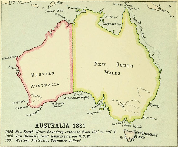
Australia in 1831
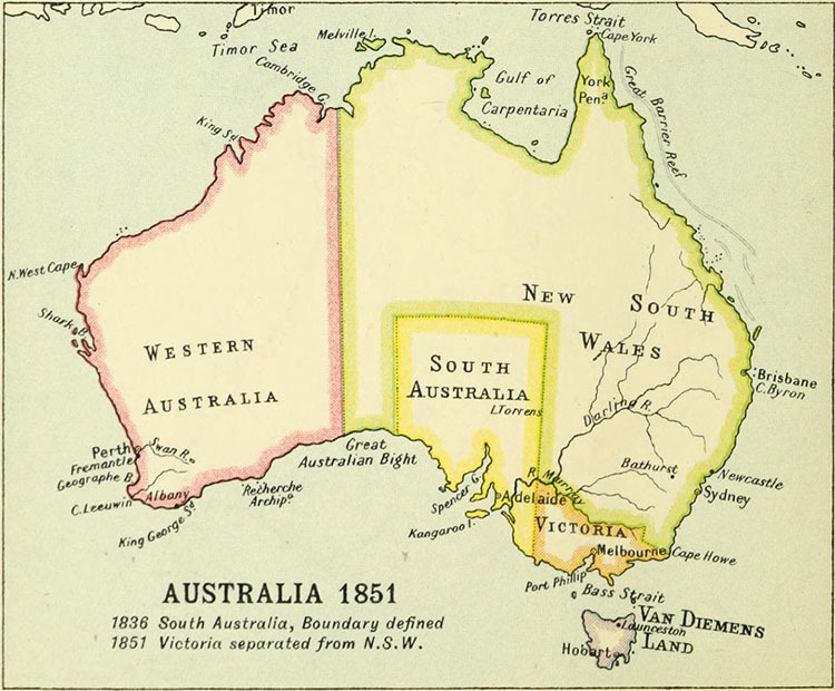
Australia in 1851
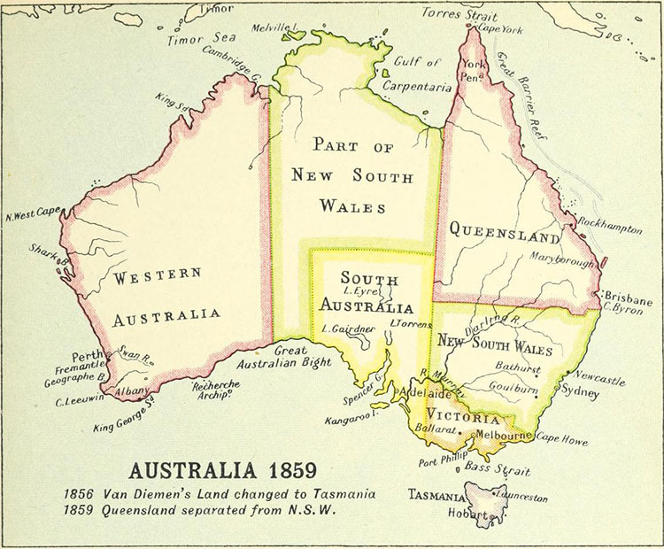
Australia in 1859
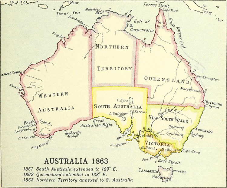
Australia in 1863
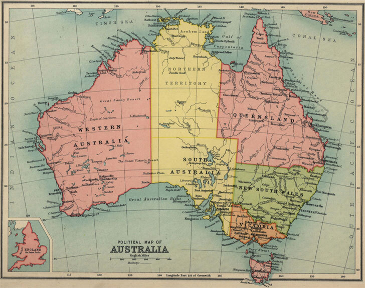
Australia in 1910
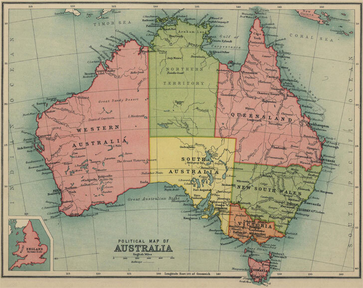
Australia in 1913
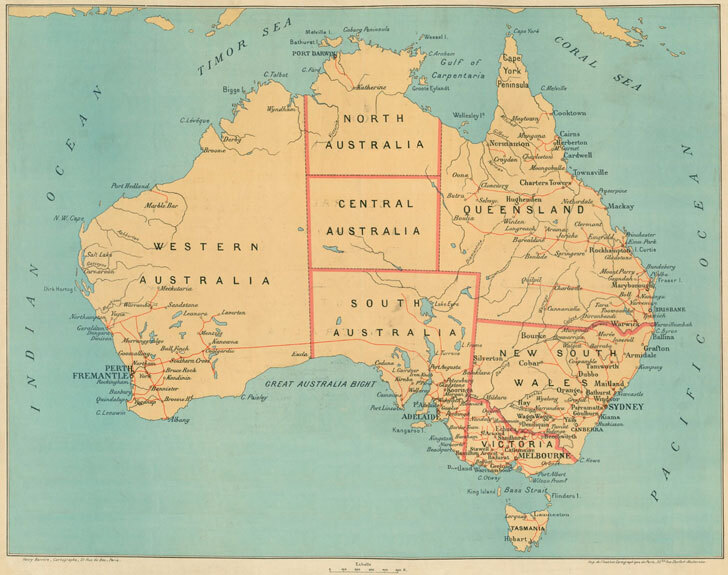
Australia in 1927
World
Albania
France
Netherlands
Spain & Portugal
Caucasus
Latin America
Ancient Greece
Austria
Germany
Poland
Switzerland
Middle East
Mexico
Roman Empire
Britain
Greece
Romania
Türkiye
Asia
Canada
Holy Roman Empire
Bulgaria
Hungary
Scandinavia
Ukraine
China
U.S.A.
Europe
Croatia
Italy
Serbia
Russia
Japan
Australia